

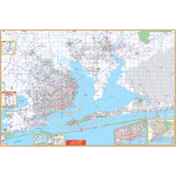

The Pensacola & Milton, Florida Wall Map of Escambia and Santa Rosa Countie. Measures 77” W x 54” H, (6'5" W x 4'6" H) has complete street detail at a scale of 1" = 2,640 feet. Provides up-to-date cartography with new streets and changes, printed in color with a markable and washable laminated surface, and framing rails mounted on the top and bottom for ease in hanging . Indexed in a separate book.
Map Coverage: North: East Black-Water River State Park and 3 miles north of Stonebrook Golf Course; South: to the Gulf of Mexico, including Pensacola Beach, Navarre Beach, and the Pensacola Naval Air Station; East: to the Okaloosa Co. line. West: to the Alabama State line; Northwest: Cottage Hill and Cantonment.
Details include: airports, cemeteries, hospitals, railroads, post offices, points of interest, longitude and latitude lines, all streets and highways, shopping centers, water features, recreational parks, fire districts, city limits and annexations, government buildings, fire and police stations, educational facilities, golf courses and country clubs, mileage circles, ZIP codes/boundaries, and section/township/and range lines. Includes an inset map of Pensacola, Jay, Northwest Florida.
2018 Edition now available.