

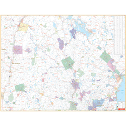

The Southern New Hampshire State Wall Map includes portions of 9 counties. Measures 68” x 54” with up-to-date cartography at a scale of 1” = 1.70 miles. Printed in color with a markable/washable-laminated surface. Cities are indexed on the map’s face. Includes hanging rails mounted top and bottom.
Covers Southern New Hampshire including the counties of Belknap, Cheshire, Hillsborough, Merrimack, Rockingham, Stafford, Sullivan, and portions of Carroll and Grafton Counties. Boundaries: North: includes Lake Winnipeasaukee and towns of Plymouth and Lebabnon; South: to the Massachusetts state line including Lawrence and Haverhill; East: to the Maine state line; West: to the Vermont state line.
Details include major streets and all highways, county lines and names, mileage circles, ZIP codes and boundaries, airports and parks, water features, and longitude and latitude lines.