

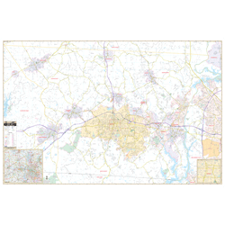

Gaston County, NC Wall Map
Regular price $199.95Our Gaston County, NC Wall Map, with adjacent areas, measures 76" x 58" (6'4" W x 4'10" H) and features up-to-date cartography, with new streets and changes in complete street detail; is printed in color, with a markable and washable laminated surface; and offers a street index in a separate book-format.
The area of coverage includes all of Gaston County, with the following boundaries:
- North to the Lincoln County line
- South to the South Carolina State line
- East to Charlotte-Douglas International Airport
- West to Kings Mountain and the Cleveland County line
The Gaston County, NC Wall Map also includes insets of Downtown Gastonia and an area map.
Details and features include:
- AIRPORTS
- BLOCK NUMBERS
- CEMETERIES
- CITY LIMITS
- EDUCATIONAL INSTITUTIONS
- FIRE & POLICE STATIONS
- GOLF & COUNTRY CLUBS
- GOVERNMENT BUILDINGS
- HOSPITALS
- LIBRARIES
- POINTS OF INTEREST
- POST OFFICES
- RAILROADS
- RECREATIONAL PARKS
- SHOPPING CENTERS
- STREETS & HIGHWAYS
- WATER FEATURES
- ZIP CODE BOUNDARIES
Framing rails are included, top and bottom, for easy wall mounting.
|
Product #: 2084330 |
|
Dimensions: Width 76, Height 58 |
|
Weight: 9.00 |