

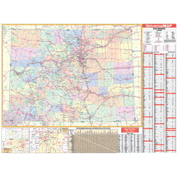

The 3rd Edition Wall Map of the State of Colorado measures 68” W x 50” H (5'8" W x 4'2" H) and uses up-to-date cartography at a scale of 1” = 8.5 miles. Printed in color with a markable/washable-laminated surface. Cities and counties are indexed on the face of the map.
Details, data, and information include all state/federal highways, secondary roads, major waterways, state universities, military installations, major airports, state and national parks, county populations, cities and towns, hospitals, wildlife areas, a mileage chart, ski areas, and points of interest.
Framing rails are included on top and bottom for easy wall mounting. Includes an inset map of Denver.