

Colorado Atlas & Gazetteer
Regular price $19.95/
Rely on a DeLorme Atlas & Gazetteer for the utmost in trip planning and backcountry access. Contains topographic maps with unbeatable detail, plus gazetteer information on great places to go and things to do. Each atlas is a quality paperback; size 11" x 15-1/2"
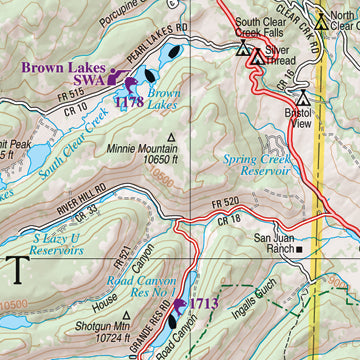
Map detail commonly includes:
» Back roads, dirt roads and trails
» Elevation contours
» Remote lakes and streams
» Boat Ramps
» Public lands for recreation
» Land use / land cover – forests, wetlands, agriculture
» Trailheads
» Campgrounds
» Prime hunting and fishing spots
Each Gazetteer entry's location is cross-referenced to the corresponding map.
Colorado Gazetteer categories
-
» Attractions -
» Campgrounds -
» Covered Bridges -
» Freshwater Fishing -
» Golf Courses -
» Historic Sites -
» Hunting -
» Recreation Areas -
» Saltwater Fishing Access -
» Trails -
» Unique Natural Features -
» Whitewater Recreation
Suggested Uses
-
» In-vehicle for everyday reference -
» Exploring back roads -
» Outdoor recreation—preparation and navigation -
» Business travel -
» Planning vacations and leisure activities -
» Armchair journeys
| Colorado Atlas Facts | |
| Scale | 1:160,000 (1"=2.5 miles) for pp. 12-93 (Fort Collins-Denver-Pueblo and west); 1:320,000 (1"=5 miles) for pp. 94-103 |
| Contour Interval | Approximately 300' |
| Each Page Covers | Topo maps on pp. 12-93 cover 25.3 miles by 35.2 miles; Maps on pp. 94-102 cover 50.5 miles x 71.6 miles |
| GPS | Grids & tick marks |
| Index | Placenames |
| Special Features | Shaded relief maps; boundaries for BLM and state lands, other publicly-owned lands highlighted; statewide publicly-owned lands locator map. |
| Pages | 92 pp. of maps, 104 pp. in all |
| Copyright | 2011 |